The commercial drone industry has evolved from experimental technology to mission-critical infrastructure across multiple sectors. As we analyze the landscape in 2026, five key applications stand out for their transformative impact, demonstrating clear return on investment and reshaping how industries approach traditional challenges. This analysis examines the current state and future potential of these game-changing applications.
The Commercial Drone Revolution: By the Numbers
The commercial drone market has reached unprecedented maturity, with industry analysts projecting global revenues to exceed $58 billion by 2026. Organizations looking to capitalize on this growth can explore UAVHQ's consulting services for expert guidance. This growth is driven not by speculation, but by measurable improvements in operational efficiency, cost reduction, and safety outcomes across diverse industries.
Key market indicators demonstrate the tangible value creation:
- ROI Achievement: 78% of commercial operators report positive ROI within 18 months of implementation
- Cost Savings: Average operational cost reduction of 45-60% compared to traditional methods
- Safety Improvements: 89% reduction in worker exposure to hazardous environments
- Data Quality Enhancement: 3-5x improvement in data collection frequency and accuracy
- Operational Efficiency: 40-70% reduction in task completion time for surveying and inspection operations
1. Precision Agriculture: Revolutionizing Food Production
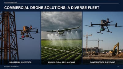
Agricultural applications represent one of the most mature and impactful commercial drone sectors, with adoption rates accelerating as farmers recognize the technology's potential to optimize yields while reducing environmental impact.
Current Applications and Impact
Crop Health Monitoring: Multispectral and hyperspectral imaging capabilities enable early detection of plant stress, disease, and pest infestations. Farmers using drone-based monitoring report 15-25% improvement in early problem identification, translating to significant yield preservation.
Precision Spraying: Autonomous spray drones have revolutionized chemical application, reducing pesticide and fertilizer usage by 20-30% while improving coverage uniformity. This precision approach minimizes environmental impact while maintaining or improving crop protection effectiveness.
Field Mapping and Analysis: High-resolution aerial imagery combined with advanced analytics provides farmers with detailed field topology, drainage patterns, and soil composition data. This information enables precision planting strategies and optimized irrigation planning.
Economic Impact
Commercial agricultural drone services have demonstrated compelling economics:
- Service costs average $5-15 per acre for monitoring missions
- Traditional aerial services cost $25-50 per acre
- Typical payback period: 8-12 months for service-based operations
- Advanced operations show 12-18% improvement in overall yield per acre
Future Developments
Emerging technologies promise to further enhance agricultural applications. AI-powered analytics are enabling real-time decision making, while swarm technologies allow simultaneous operation of multiple aircraft over large acreage. Integration with autonomous ground equipment is creating fully automated farming systems.
2. Infrastructure Inspection: Enhancing Safety and Efficiency
Infrastructure inspection represents perhaps the most immediately compelling commercial drone application, addressing critical safety concerns while delivering substantial cost savings and operational improvements.
Power Generation and Transmission
Wind Turbine Inspection: Drone-based inspection has transformed wind farm maintenance, reducing inspection costs by 60-80% while improving safety outcomes. High-resolution imagery and thermal analysis enable detection of blade damage, bearing issues, and electrical problems without costly crane deployments or worker safety risks.
Solar Farm Monitoring: Thermal imaging drones can survey entire solar installations in hours rather than days, identifying faulty panels, hot spots, and electrical issues that impact generation efficiency. Operators report 25-40% improvement in problem detection speed.
Power Line Inspection: Helicopter-based power line inspection traditionally costs $1,000-3,000 per mile and involves significant safety risks. Drone-based inspection reduces costs to $100-400 per mile while providing superior data quality and eliminating crew risk exposure. However, operators must navigate increasing security considerations in sensitive infrastructure zones.
Transportation Infrastructure
Bridge Inspection: Traditional bridge inspection requires expensive scaffolding, traffic disruption, and worker safety considerations. Drones enable comprehensive structural assessment with minimal traffic impact and no worker exposure to heights or traffic hazards.
Highway and Railroad Monitoring: Regular surveillance of transportation corridors identifies maintenance needs, safety hazards, and unauthorized access issues. Automated flight systems enable routine monitoring without human resource deployment.
Oil and Gas Infrastructure
Pipeline inspection via drone has become standard practice for major operators, with methane detection sensors identifying leaks that traditional methods might miss. Thermal imaging capabilities detect equipment anomalies before catastrophic failures occur.
3. Emergency Response and Public Safety: Saving Lives and Property
Public safety agencies have embraced drone technology as an force multiplier that enhances response capabilities while improving officer and civilian safety.
Search and Rescue Operations
Rapid Area Assessment: Drones equipped with thermal imaging can survey search areas in minutes, identifying potential victim locations that might take ground teams hours to reach. Success stories include numerous life-saving operations where thermal signatures led to rapid victim location.
Maritime Rescue: Coast Guard and marine rescue units utilize drones for rapid initial assessment of maritime emergencies, enabling more efficient deployment of rescue assets and improving situational awareness for response teams.
Disaster Response and Assessment
Post-Disaster Damage Assessment: Following natural disasters, drones provide rapid damage assessment capabilities that inform resource allocation and emergency response priorities. Traditional assessment methods might take weeks; drone-based assessment can be completed in days.
Firefighting Support: Wildfire response teams utilize drones for real-time fire perimeter mapping, hotspot identification, and resource deployment planning. Night operations with thermal imaging provide 24-hour situational awareness previously unavailable to incident commanders.
Law Enforcement Applications
Police agencies report significant improvements in operational effectiveness through drone deployment. Crowd monitoring, traffic accident investigation, and tactical situation assessment benefit from aerial perspective and real-time intelligence gathering.
4. Logistics and Delivery: The Future of Last-Mile Transportation
While still emerging compared to other applications, logistics and delivery operations are demonstrating the potential to revolutionize last-mile delivery, particularly in challenging geographical areas and time-sensitive medical applications.
Medical Supply Delivery
Rural Healthcare Support: Medical drone delivery has proven particularly valuable in rural and remote areas where traditional delivery methods are slow or impractical. Blood products, medications, and medical samples can be transported quickly and safely, improving patient outcomes and reducing healthcare costs.
Emergency Medical Response: AED (Automated External Defibrillator) delivery drones are being deployed in several metropolitan areas, providing life-saving equipment to cardiac emergency scenes faster than traditional emergency vehicles.
Commercial Package Delivery
Limited commercial delivery operations are demonstrating the viability of drone delivery for specific use cases:
- Time-sensitive deliveries (prescription medications, emergency supplies)
- Remote location delivery (islands, offshore facilities, rural areas)
- High-value, small package delivery requiring enhanced security
Economic and Operational Considerations
Current delivery operations show promising economics for specific applications, with costs comparable to expedited courier services while offering superior delivery times for suitable packages and routes. However, safety incidents like recent Amazon drone crashes highlight the importance of robust safety systems as the industry scales.
5. Construction and Surveying: Transforming Project Management
Construction and surveying applications have achieved widespread adoption due to clear productivity improvements and enhanced project management capabilities.
Site Surveying and Mapping
Topographic Surveying: Drone-based surveying reduces traditional survey costs by 50-75% while improving data collection speed and safety. Photogrammetry and LiDAR-equipped drones provide centimeter-level accuracy suitable for construction planning and engineering applications.
Volumetric Analysis: Stockpile measurement and earthwork calculation via drone are now standard practice for large construction projects. Regular monitoring enables precise material tracking and project progress assessment.
Construction Progress Monitoring
Project Documentation: Regular aerial photography and videography provide comprehensive project documentation, supporting progress reporting, change order justification, and dispute resolution.
Safety and Compliance Monitoring: Aerial observation identifies safety violations and compliance issues that might be missed by ground-based inspection, improving overall project safety outcomes.
Quality Assurance and Inspection
Drone-based inspection enables access to difficult or dangerous areas of construction projects, improving quality assurance while reducing worker safety risks. Thermal imaging capabilities identify insulation issues, moisture problems, and structural anomalies during construction. Advanced platforms like heavy-lift drones are expanding capabilities for material transport and specialized equipment deployment on construction sites.
Cross-Industry Success Factors
Analysis of successful commercial drone implementations reveals common success factors across all applications:
Technology Integration
Successful operations integrate drone capabilities with existing business systems and workflows rather than treating drone technology as standalone solutions. Data integration, automated reporting, and workflow incorporation are essential for realizing full value.
Regulatory Compliance
Organizations that invest in comprehensive regulatory compliance frameworks, including appropriate Part 107 waivers and safety management systems, achieve more consistent operational success and regulatory acceptance.
Personnel Training and Development
Investment in comprehensive pilot training and ongoing professional development correlates strongly with operational success and safety outcomes. Organizations treating drone operations as professional aviation functions achieve superior results.
Data Management and Analytics
The true value of commercial drone operations often lies in data analysis and actionable insights rather than the flight operations themselves. Organizations with robust data processing and analysis capabilities realize greater return on investment.
Future Outlook: The Next Phase of Commercial Aviation
The commercial drone industry is transitioning from early adoption to mature implementation. Several trends will shape the next phase of development:
Autonomous Operations
Advances in autonomous flight systems and artificial intelligence are enabling more sophisticated operations with reduced human oversight, particularly in beyond visual line of sight (BVLOS) operations. This evolution will further improve operational economics and enable new applications previously impractical due to labor costs.
Advanced Air Mobility Integration
The integration of commercial drones with emerging Advanced Air Mobility systems will create new operational capabilities and airspace management frameworks, enabling more complex missions and higher-density operations.
Swarm and Multi-Aircraft Operations
Coordinated multi-aircraft operations will enable large-scale missions previously impossible with single-aircraft limitations. Agricultural applications, in particular, will benefit from swarm capabilities enabling rapid treatment of large acreage.
Conclusion: The Maturation of Commercial Aviation
Commercial drone applications have evolved from experimental technology to mission-critical infrastructure across multiple industries. The five applications examined—precision agriculture, infrastructure inspection, emergency response, logistics, and construction—demonstrate clear value propositions with measurable returns on investment.
Success in commercial drone operations requires treating unmanned aviation as professional aviation, with appropriate investment in training, safety systems, regulatory compliance, and data management capabilities. For a step-by-step approach, see our guide to building a commercial drone program. Organizations that approach drone implementation strategically, with focus on integration rather than standalone applications, achieve superior operational outcomes.
As the industry continues to mature, the most successful operators will be those who leverage drone technology not as a replacement for existing capabilities, but as an enhancement that enables new levels of operational efficiency, safety, and data-driven decision making.
The commercial drone revolution is no longer a future possibility—it's a current reality reshaping how industries operate. Organizations that have not yet explored these applications risk competitive disadvantage as drone-enhanced operations become standard practice across sectors.
Share this analysis:
Related Articles
The State of FAA Part 107 Waivers in 2026
Comprehensive analysis of regulatory landscape and waiver approval trends.
BVLOS Operations: What You Need to Know
Essential guide to Beyond Visual Line of Sight operations and requirements.
📺 Watch the Video Briefing
Get expert video analysis on this topic and more on the UAVHQ YouTube channel.
🚁 Stay Ahead of the Drone Industry
Expert analysis on FAA regulations, commercial operations, and emerging technology — delivered to your inbox.
Subscribe
Consulting Intake Paused
UAVHQ is not currently accepting new consulting clients. Existing commitments remain supported; select time-sensitive safety or regulatory inquiries may be reviewed as availability allows.
Sponsored by
Your Brand Here
Reach drone professionals, commercial operators, and aviation decision-makers.
📺 Watch the Video Briefing
Get expert video analysis on this topic and more on the UAVHQ YouTube channel.
🚁 Stay Ahead of the Drone Industry
Expert analysis on FAA regulations, commercial operations, and emerging technology — delivered to your inbox.
Subscribe
Sponsored by
Your Brand Here
Reach drone professionals, commercial operators, and aviation decision-makers.
UAVHQ
Drone industry intelligence and professional UAV consulting from Wesley Alexander — Senior Test Pilot with 25+ years of aviation leadership.
Explore
Connect
© 2026 UAVHQ. All rights reserved. · Privacy Policy